


A few weeks ago I shared The 1806 Administrator Bond for the Estate of William Johnson Sr. (1755-1805) and followed it up with last week’s post Time to Pull up Stakes and Move on about the land William and Amy sold in 1798 in Greenbrier County before moving to Kanawha County in what is now West Virginia.
William JOHNSON Sr. (1755-1805) and Amy NELSON (1757-1837) were my 5th great-grandparents. From the wording of the two land deeds, they were a part of an original 150 acres land grant. These are the steps I took to show the land they sold was the same land granted to William in 1796.
Plotting the Tracts
Early this year I tried my hand at abstracting call lines from a deed and plotting the tract. I found the tract on a present-day map and wrote about the tools I used in I Found the Coolest Site to Use for Land Records in West Virginia.
As I had been successful with my CLONCH ancestor’s land, I tried the same tactic with William and Amy’s two land tracts. I used the following tools:
Johnston to Tennis, 62 acres on Lick Run
As I had already transcribed the deeds all I needed to do was to abstract the call lines and convert the poles to feet for the Tract Plotter. For the Johnston to Tennis land deed:
Begining at a Double white oak and chesnut corner to the old survey & thence through the survey south Eighty three Degrees East one Hundred & twenty pole
Call Line: S83E 120 poles (1980 ft)
to an aposite Corner of the old survey & Flathers & with old line North Thirty six Degrees west one Hundred and sixty eight pole
Call line: N36W 168 poles (2772 ft)
to four Locusts and soth (sic) Seventy Degrees wet forty four Pole
Call line: S70W 44 poles (726 ft)
to two white oaks & South thirteen Degrees East one Hundred and fourteen pole to the Begining
Call line: S13E 114 poles (1881 ft)
As can be seen below the call lines for the Johnston to Tennis tract calculate to 59.6 acres while 62 acres were seen in the deed.

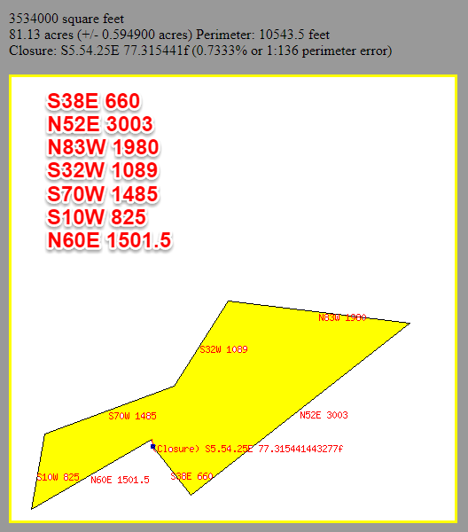
Johnston to Kounts, 88 acres on Lick Run
The same was done for the Johnston to Kounts land deed:
Beginning at a black Oake & White Oake Corner to Kouns and with South thirty Eight Degrees East forty pole
Call line: S38E 40 poles (660 ft)
to two white oaks and North fifty two Degrees East one Hundred and Eighty two pole
Call line: N52E 182 poles (3003 ft)
to Red Oak & two white oaks Corner to Keenan and the old Survey, thence through the Survey with Tineses line North Eighty three Degrees West one Hundred and twenty pole
Call line: N83W 120 poles (1980 ft)
to the apasite Corner of old Survey and c? to Tennis on a Double White Oak and Chesnutt Oake on a Ridge and with old line South thirty two Degrees West Sixty six pole
Call line: S32W 66 poles (1089 ft)
to Chesnutt Oake and black Oake and South Seventy Degrees West Ninety pole
Call line: S70W 90 poles (1485 ft)
to two white oaks and South ten degrees west fifty pole
Call line: S10W 50 poles (825 ft)
to two White Oak Corner to Kounses own and with North Sixty Degree East Ninety one pole to the Beginning
Call line: N60E 91 poles (1501.5 ft)
The Johnston to Kounts tract calculates to 81.13 acres while 88 acres seen in the deed.
Merging the two tracts
After plotting the tracts I combined the two. The call lines N83W 1980 ft (Kounts) and S83E 1980 ft (Tennis) are the common boundary mentioned in the deeds. To combine them I used PicMonkey. The Tennis tract was reduced in size to match the scale of the Kounts tract.

The original 150 acres land grant
I looked at the original land grant of 150 acres only after I’d plotted the two land tracts side by side. I transcribed the description of the land, plotted the call lines, and came up with the same boundaries seen in the image (above) where the two were attached to each other.
…lying and being in the County of Greenbrier on the waters of Indian Creck a branch of New River and adjoining the Land of Patrick Kenan, Edward Fleathers and Samuel Black and bounded as followeth to wit. Beginning at a black and white oak, corner to Kenan and with the same South thirty eight degrees East forty poles two white oaks North fifty two degrees East one hundred and eighty two poles to a red oak and two white oaks on Fleathers’s line and leaving the same, North thirty six degrees West one hundred and sixty eight poles to four Locusts, South seventy degrees West forty four poles to two white oaks, South thirteen degrees East one hundred & fourteen poles to a double white and Chesnut oak, on the top of a hill thence South thirty two degrees West sixty six poles to a Chesnut and black oak, South seventy degrees West ninety poles to two white oaks, South ten degrees West fifty poles to two white oaks corner to Kenan thence North sixty degrees East ninety one poles to the beginning…
Call lines:
S38E 40 poles (660 ft)
N52E 182 poles (3003 ft)
N36W 168 poles (2772 ft
S70W 44 poles (726 ft)
S13E 114 poles (1881 ft)
S32W 66 poles (1089 ft)
S70W 90 poles (1485 ft)
S10W 50 poles (825 ft)
N60E 91 poles (1501.5 ft)

Where was the land grant found?
Years ago I discovered The Library of Virginia‘s collection Virginia Land Office Patents and Grants/Northern Neck Grants and Surveys. A search turned up a land grant in Greenbrier County for one William JOHNSTON described as 150 acres on the waters of Indian Creek a branch of New River and adjoining the lands of Patrick Kenan (sic), Edward Heathers (sic), & c.
At the time I knew Patrick KEENAN was a neighbor as my 6th cousin David Fridley had found the records of sale for two tracts of land totaling 150 acres and extracted only the short description of the land. It appeared to be a match but without the 1798 records which I transcribed in my previous post, I couldn’t be 100% certain.
Now with all three deeds “in hand,” I was able to compare and prove the 150 acres granted to William JOHNSON on 10 May 1796 is the same land he sold in two parcels in June 1798 to TENNIS and KOUNTS.
Questions remain
William JOHNSON used the Land Office Treasure Warrant number 12841 issued 2 July 1782 to obtain the grant of 150 acres in 1796.
On the Kentucky.gov Portal, they have a searchable database that includes all Virginia Treasury Warrants. I searched for the warrant number William used and found it was in the name of Edward KENON for 1470 acres.
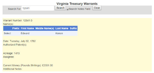 Why would William JOHNSON use a treasury warrant issued to Edward KENON (KEENAN)?
The Library of Virginia has an interesting guide states, “At any time in the grant process after the treasury warrant was purchased, the purchaser could assign (sell) the right to part or all of the land described in the warrant.”
Apparently, Edward KEENAN assigned or sold the right to 150 acres of the original 1470 acres he purchased to William JOHNSON. Could there be a story behind this? Why did William JOHNSON sell the land only two years after he received the grant?
A complete transcription of the 1796 land grant to William JOHNSON will be share in a later post. Next week I’ll be making an announcement…

© 2019, copyright Cathy Meder-Dempsey. All rights reserved.


Incredible work, Cathy. I’d never have the patience for it myself, so I admire what you have done.
LikeLiked by 1 person
Thank you, Amy. I know this is an area not everyone is interested in. On the other hand people may not know what they can do with the records other than attach them to their ancestor. I hope my post will make them take another look.
LikeLiked by 1 person
I don’t think I will ever get to the point where I am capable of tracing land plot lines. Not necessarily lack of interest, just lack of motivation. Or maybe that’s the same thing. Plus most of my US ancestors lived in cities…
LikeLiked by 1 person
Amy, I agree, you don’t have the motivation since most of your ancestors lived in the city. I’m sure you would be capable of tracing land plot lines if you had persons of interest who owned land.
LikeLiked by 1 person
Your research is amazing Cathy. William Edward Johnson and Amy Nelson were my 4th great-grandparents. My father was also named William Edward Johnson (1914-1976), born in Beckley, West Virginia. Thank you for your hard work.
LikeLiked by 1 person
Thank you, Lynn. I would really like to know where others are finding the middle name Edward for William JOHNSON Sr. This is one of the reasons I have been looking into his records again. I have not found a record so far in which he has a middle initial or name. Since your father did have this name, perhaps you have more information on the name of your 4th and my 5th great-grandfather.
LikeLike
Amazing research, Cathy. I love the tools available.
LikeLiked by 1 person
Thank you, Dara. I love the tools available too. We just need to learn how to use them.
LikeLike
Hi Cathy, Well, besides genealogically speaking, with surveying, your speaking my language. One of the very first things I did at Michael Baker Engineers 1979-1982, was plotting deeds. Most of the time they did not close. Also, Patrick Keenan and Edward Keenan are my wife’s direct ancestors. Wow, very cool. Great post! Brian
LikeLiked by 1 person
Thought you would like this, Brian. Thanks for the praise.
LikeLike
Awesome detailed work – A great read and information 🙂 Sharon
LikeLike
Thank you, Sharon. Always nice to hear from you. 🙂
LikeLike
I hope that announcement is you live-blogging/tweeting/facebooking from this Virginia land!
LikeLiked by 1 person
Sorry to disappoint you, Michael. If only I had a fairy godmother who could grant me all my wishes.
LikeLike